

STORIES, ARTICLES, & NEWS ABOUT ACT 181
The Perspective of an Environmentalist and Ecological Land Planner
ben falk, m.a.l.d. post
This Act 181 is a truly insane piece of legislation. I say this as a life-long dyed in the wool actual environmentalist and ecological land planner of 25 years who's planted 12,500+ trees, has made a career of advancing watershed health and have been working in forest and wild land protection for my entire adult life. This is being flown under "environmental sustainability" as the purported goal but it seems that this can't be it.
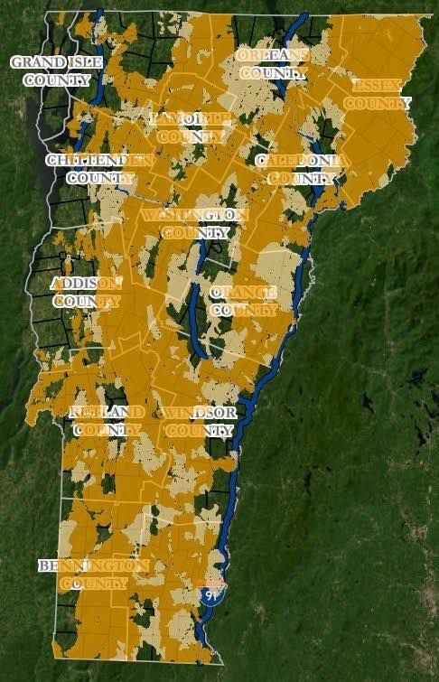
They show wildlife corridors randomly starting and ending along roadways and highways. They show high ridges and deer yards sometimes mapped yet often unnoticed. High sensitive headwaters - the same - some noted, many ignored.
It's like an AI-assisted intern project of the entire state - fun perhaps as a an academic exercise but nothing you could make laws from that affect real people in real ways. It would take an army of field techs and years to make half decent maps with these implications across an area of 6 million acres. Maybe decades. You'd have to ground truth all boundaries of consequence, which are most.
It is unimaginable how these regs would/could even be enforced. Tens of thousands of landowners would be in violation in the first year simply due to normal work they do on their property.
But the most chilling part might not be that such sweeping culture-changing regulations could descend from central planners in closed door meetings without huge public input, it's that no one - not NGO leaders promoting it nor legislators who support it - will justify any of it specifically. Their only refrain is "environmental sustainability" and "affordable housing." All while passing a bill that will crush new rural housing opportunities and many existing rural livelihoods as well.
It seems to be a class war on rural peoples. I'd love to hear any justification of it's content by any representatives or any citizens. Thus far it seems that no one is even defending the contents of the legislation but spending all of their messaging attacking those who want it repealed, as though they are confused or spreading "misinformation."
Dara Torre, Candice White, Anne Watson, Ann Cummings, Andrew Perchlik please, tell it to me like I'm 10 years old - I would love to be wrong about this. You are tagged below so you or your staff will likely see this post.
If anyone can tell me why wildlife corridor would be planned only along/parallel with roads including major state highways, I'm all ears. I've planned wildlife corridor for clients for 20 years, studied it via Dave Foreman's original continental wildlands work directly for 30 years and understand quite well how corridor as a design strategy works. This mapping is antithetical to sound corridor design which seeks safe crossings, not prolonged interaction between wildlife and highways/roads. In general good corridors facilitate the movement of animals away from vehicular corridors and when that's not possible they aim for quick crossings.
Where are the steep slopes on this map? That's a 30 year old GIS layer and the starting point aside from wetlands for protecting sensitive areas. 30% grade or up (or similar) would be a base layer for these maps yet it's non existent.
Where are many upper watershed creeks and recharge areas mapped? There are some but at least 50% of them are missing. These are also a critical starting point. I am not referring to areas above 2500' (Act 250 protected - great!). I am talking about where many of then lay in the state between roughly 1500 and 2500.
Can ANY one justify these maps and this approach from a sound ecological and working lands perspective?
Editors note: Ben, and the rest of us, are still waiting for answers.
share this
MORE READING MATERIAL
Related Articles
STAY UP TO DATE
sign up to our newsletter
Receive bi-weekly updates about the latest news about Act 181
Contact Us